How Aerial Imagery Changed Our Perception
When looking at the Bengali landscape through an aeroplane window, we see scattered settlements with mostly water, paddy fields, trees, and some paths. Additionally, there is also the plane itself being inserted into the scenario, where it acts as the spectator. “The will of the aeroplane represents to me the real spectator who gazes out through the aeroplane window and experiences the sublime landscape,” notes Adnan Morshed, architect, professor and historian.
What does it mean to be an aerial spectator? When you are on an aeroplane, you do not see a ready-made landscape, but you rather interpret that landscape. Both landscape and scale then become discourses. When the pyramids were designed, the architects intended it to be viewed from the ground. This was because the huge scale of the pyramids was intended to overwhelm spectators. The massive scale demanded reverence and submission to an idea. However, that reverence is completely gone when one is viewing the pyramids from the top, from an aeroplane. From such a height, the pyramids appear to be miniature, playful things like toys although that was never the intended viewing angle. When one views an object like a toy, that cannot evoke any kind of reverence or spirituality. As a result, mankind’s ability to fly completely altered the way we view pyramids. The same shift in perception can apply to other buildings like the National Assembly Building of Bangladesh, the United States Capitol or even an entire forest like the Sundarbans.
When one visualises an architectural work from an angle that was not the intended viewing angle by the designer, the meaning of architecture changes; it transforms into something new. “Miniaturisation becomes a discourse,” believes Adnan Morshed. “Your viewing angle can give a new meaning to the object you are looking at. But that angle also creates a new spectator, which is you.”
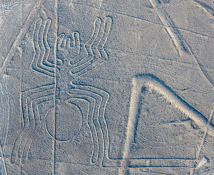
Nazca Lines in southern Peru from an ancient civilization are another fantastic experience for an aerial spectator. These are ancient motifs on the ground in the Nazca desert, which make up various interesting shapes and figures. The wonderful thing about these geoglyphs is that they were designed to be seen from the top. Only when you are flying above the land, you get to see the fascinating drawings of monkeys, dogs, pottery and mythical figures. Since Nazca Lines can only be seen from the top, we did not know about their existence until the 20th century, when we learned how to fly. Although the drawings were discovered first in the 1920s, the artists of these drawings remain unknown till date, however many speculations have been made about them.
There is a prehistory behind the sublime experience we have when we are viewing an object from the top. In medieval times, looking from above had been described as the perspective of god. In medieval literature, it was theorised that god as an architect was using some kind of perspective to build the universe. This theory has been twisted in many discourses of the 20th century in which the architect is being referred to as god, as he designs cities from impossible heights and unusual angles. The ability to create geographies at different scales gives some kind of omnipotent power to the architect.
A related narrative is that a philosopher too has a god-like vantage point. A philosopher is one who can make connections between different fields, believed Denis Diderot, French philosopher and a prominent figure during the Enlightenment in Western Philosophy, the intellectual and philosophical movement that influenced Europe during 18th century. A philosopher is defined by his ability to endure the power of scale. However, during the Enlightenment period, we did not have the power to see things in their geographic construction.
It all changed during 19th century, with the invention of the hot-air balloon that gave us a new perspective and vantage point for the first time. In the year 1858, in Paris, a photographer and balloonist Gaspar Felix Tournachon, referred to as Nadar, took the first known aerial photograph[1]. This was revolutionary back then, because this was the first time one could view a city in a whole new light. It helped people identify iconic landmarks of Paris like Arc de Triomphe and the Louvre. In a way, that first aerial photograph was more about a discovery and marvel of technology than a discourse.

Lithograph: Honoré Daumier, appearing in Le Boulevard, May 25, 1863
In the Renaissance period, there was a system where cartography could be transitioned into an aerial perspective. So one may wonder, why is aerial perspective suddenly so crucial now given that it was possible long before 20th century? The answer lies in the fact that, in the 20th century, it created a discourse.
We are seeing different kinds of spectatorships in the 20th century onwards leading to different kinds of experiences of the city, and this is due to technological advancements. From the top, we see a different kind of spectacle, compared to the scale of the city which we experience as pedestrians. Consequently, that spectator creates a new kind of narrative of urban life. Different kinds of urban analyses were made possible due to difference in vantage points, and that became a kind of operative knowledge. This knowledge became an instrument for intervention, which is affecting us today and will influence the future.
References:
“History of Aerial Photography.” PAPA International: Professional Aerial Photographers’ Association. https://papa.clubexpress.com/content.aspx?page_id=22&club_id=808138&module_id=158950&sl=968801655.